Saturday, August 6, 2011

Seychelles Beaches


The Island - Seychelles

At the very dawn of time, when the shape of the our planet was still evolving, the giant continent of Gondwanaland broke apart and a group of ancient granite fragments finally came to rest in the south-western Indian Ocean between Africa, India and Madagascar.

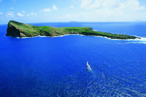
Today, The Seychelles archipelago's 115 granitic and coralline islands lie spread like emeralds over one million square kilometers of azure water just south of the equator. The granitic islands cluster around the principal island of Mahe while the more numerous islands extend in a gleaming arc towards the East Africa. Most remain virgin worlds. All remain sanctuaries to some of the rarest and most exotic plant and animal life in the known world. Unspoiled

Seychelles Inner Island:
The granitic islands of Mahe, Praslin, and La Digue together with their satellites from the cultural heart of the archipelago. Gateway to Seychelles and home to the International Airport.

 
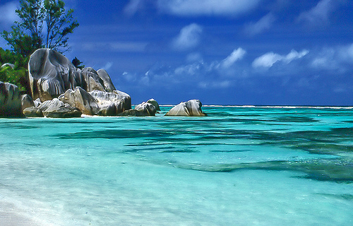
Anse Source d'Argent harbours a rich underwater world. Praslin's legendary Coco-de-mer nut grows on ancient giant palms in the wondrous Vallee de Mai Forest. Time stands still on La Digue where on-carts hold sway on the paths to the dream beach of Anse La Sourced Argent. The Norternmost coral islands of Bird Island andDenis Island offer unforgettable sights of the turtles nesting on ivory sands and, on Bird Island, of millions of sooty terns, which colonise part of the island every year. East of Mahe lies Fregate, showcase for several endemic species of fauna.

Seychelles Outer Island:

The Outer Island are situated beyond the Seychelles plateau comprising of 73 low lying islands between 230km and 1150 km from Mahe.
Only two islands among the Outer Island groups, Alphonse and Desroches offers accomodation


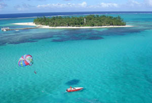
Beaches in Seychelles:

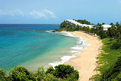
Seychelles is home to some of the most picturesques beaches in the world. Beaches in Seychelles are uncrowded and pristine.

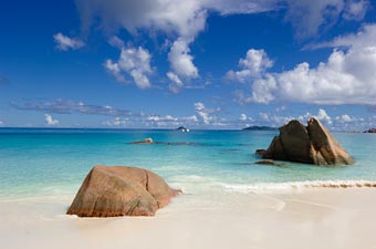
Some like famous Anse Source d'Argent on La Digue, are framed by impressive granitie rocks. Anse Cocos on the eastern coast of La Digue is only accessible by foot. Anse La Reunion lies along its shore on The La Digue Island. Anse Patates lies on the northern most tip of the La Digue and is close to the Patatran Village. When walking along the famous Anse Source d'Argent, continue across the small river untill you reach Anse Pierrot. Anse Union
beach is a part of the L'Union Estate, a plantation open to the public.


Attractions in Seychelles:

In addition to the world famous beaches of Seychelles, there are a host of special attractions in Seychelles for the visitors. These include the legendry Vallee de Mai in Praslin. L'Union Estate in La Digue Island is home to the one of the most pristline beaches in Seychelles.

Aride Island, is one of the world's most important Nature Reserve. Aride Island is home to breeding seabirds of ten species endemic birds such as Magpie Robins, Fodies, Brush Warblers. Ile Coco Marine National Park is set around 3 small islet in shallow turquoise sea by large expanses of coral reefs. The combination of red and green, colour the hillside of Curieuse Island and gives it its unique characteristics. The hills are peppered with Coco de mer trees, of the eternal symbols of the Seychelles.


Most visitors vist The Curieuse Marine National Park by chartered boad from Praslin. Standing at a height of 740 m Silhoutte Marine National Park is the only "paper park" left in Seychelles. Set in turquoise sea Anne Marine National Park has one of the largest areas of sea grass meadows in the granitic islands.


Island of Bali, Indonesia


Bali Beaches


Bali beaches.... from palm fringed white sand on the east coast to the wilder black sand beaches on the west coast, with sleepy undisturbed coves in-between.

Once the haunt of surfers, Bali's beaches now welcome visitors in search of paradise with superb hotels and excellent facilities. Check our beach guide.

Kuta Beach


Kuta, located in southern Bali, was a sleepy fishing village half a century ago, but it has slowly expanded since the 1960s after its long sandy beach was discovered by travellers from Asia and wandering surfers from nearby Australia.

Nowadays Kuta is quite busy and packed with varied accommodation from four-star hotels to budget hostels. Cheap bars and clubs make it a party centre, while local and international restaurants offer great dining. Kuta also offers shopping aplenty, from the chic beachfront ‘Discovery Shopping Mall’ and Kuta Square to the souvenir shops lining Jalan Kartika Plaza, Jalan Pantai Kuta and up to Legian and Seminyak – all within easy walking distance.

Kuta has its own beauty and attractions and remains one of Indonesia’s major tourist destinations; particularly during the peak season from July to August and the holiday season for Christmas and New Year: at these times Kuta will be fully booked by a local younger crowd, Asian travellers and Australian teenagers who are intent on enjoying an affordable vacation in Bali.

Legian Beach


Legian is probably the second most popular area with visitors after Kuta because of its close association with beach life and its parties. Indeed, one of Legian’s main attractions is its extravagant night life. Another attraction is the white sandy beach filled with tanned wannabe celebrities.

For first timers Legian is just like another Kuta but give yourself a day, and an evening walk along the famous Double Six Beach, and a night in a cosy club, then you decide what you’ll do with the rest of your vacation.

Seminyak Beach


A few miles north of Kuta is Seminyak which is the hippest part of southern Bali. More upmarket than Kuta and home to Bali's best bars, clubs and restaurants with new places opening almost weekly. Creative energy is the phrase that best sums up Seminyak, energy which also extends to the fashion boutiques.

Cool comes at a price, featuring strongly are world class hotels and resorts located next to the beach. Expect prices to be a little higher than Kuta.


Island of Ibiza


IBIZA BEACHES

Ibiza has some of the most magnificent beaches in the Mediterranean. Most people think of Ibiza as a party island. Well, if you take the time to drive around the island, you will discover some excellent and almost deserted beaches.


Most of the quieter beaches can be found in the north of the island. Try visiting Xarracca , Rencli de S'illot or Xuclar. When I visited these beaches at the beginning of the season there were only one or two people on them. Have a look at the Xarracca pictures and you will see what I mean.

Cala Vadella (near Es Vedra ) is a really nice bay, it's closed off from the sea, so if you can't handle heat keep away from here. The water is completely calm and crystal clear, ideal for snorkelling or diving. You can hire jet skis, pedaloes, relax and have a massage or go for a snack or meal at one of the excellent restaurants. Sundays here is particularly busy and parking can be a problem, but worth the effort. If you are a strong swimmer, it is possible to swim to Es Vedra
Ibiza beach
If you don't have access to a car and are in San Antonio, go down to the marina and take boats to Cala Bassa or Cala Conta , both of these beaches are excellent for families, as the water is very shallow for a long way out and is usually very calm. Cala Conta is the better of the two, but the boats do not go there on Sundays.

San Antonios' beaches are not really up to much, thought they were rebuilt earlier in the season, but if you don't have time to go anywhere else, they will do. Try get a space in front of Itaca, next door to Bar M and when the sun goes down, you can pop in for a meal. The prices are very good and their standards are very high. You can get two meals including a drink for under 15€ / £10.

Cala Salada is very popular with locals on Sundays and the restaurant here is usually busy, it's not the least expensive, but again, the standard is very good.


Ambergris Caye Beaches, San Pedro, Belize

Ambergris Caye

Ambergris Caye San Pedro Belize

What comes to mind when you think of Belize? If you’re like most, it’s “diving”. Some older folk may think British Honduras, but we think cute, small beaches. You can’t get away from the diving culture here. Some of the top dive spots are here. So plan at least a snorkel trip.

Fishing in Ambergris Caye San Pedro Belize

This paradise is just sitting here waiting for you. There is good reason why dive companies keep coming back here over and over. Belize has super-clear water, and tons of friendly fish. And if you have dived Belize, we’d like to know about it. Write us.

We’re in Ambergris Caye, and as you can see, the turquoise waters here are the clearest in the Caribbean. You can easily see the bottom at several points around us. And this part of the coast off Belize is alive with fish and all manner of marine life. Because locals are trying hard to keep this place green, the work is paying off and tourist keep coming back. Is is sustainable?

Parrot fish, bull sharks, Spanish mackerel, yellow tail snapper, barracuda, all make their home here.Sport fishing is as good here as it is off Los Cabos.

Ambergris Caye San Pedro Belize

And the beaches are much better according to some. Belize is the best of both worlds: friendly and full of marine life. Now a prime destination for those eager to swap gray skies and chilly weather in the north for blue water and fresh seafood. If you’ve been to several Caribbean islands, but want something different, Belize might be your place.

And, hey, they speak English here! People seem truly grateful for every tourist, and you just can’t overlook the brilliant, varied marine life that snorkelers and divers love.Belize mainland is 180 miles long and around 68 miles at the widest point. But if you’ve heard of Belize, it’s probably because of its famous “cayes” or islands. More than 200 of them dot the coastline inside the world’s second-largest coral reef.

You’ve probably already booked your trip here, but if not, shop around to see what you can get on air and land packages. There are awesome diving packages as well. Find the best deal, compare prices and read what other travelers have to say about hotels in San Pedro

Ambergris Caye San Pedro BelizeBelize is about a 2-hour flight from Miami and Houston. Direct flights are available in several U.S. gateway cities, and from Cancun and Chetumal, Mexico. In-country airlines are Tropic Air and Island Air, serving Ambergris Caye, Caye Caulker, Caye Chapel, Corozal, Placencia and Punta Gorda.

Food is good and the atmosphere is totally Caribbean, which means leave the stress back in the office back in your country. Close your eyes, take a deep breath and come find what God put here for you. Everyone is laid back here and hurry is not a word they know. And for good reason! Now, let’s hop over to some of the beaches. We’ll start out with the ones around here, Ambergris Caye, home to the town of San Pedro.

Ambergris Caye Beaches San Pedro Belize

Yes, there are beaches in Belize, but not many. Ambergris Caye has a few worthy beaches, but remember, what makes a pristine diving location is the fact there isn’t much sand around. And so it is with Belize. This place is easy to get to and not far from the USA, so it’s worth a visit if you want to have a little beach time, but really want to see the creatures under the sea. Make sure you get some online reviews of dive operations before you head here. There are some good salespeople on these shores. Also, get your expectations addressed in advance so you won’t be disappointed.

Ambergris Caye Beaches San Pedro BelizeFirst, there are a few excellent beaches that line the resorts and have full facilities and are open to the public. You can generally tell when the beach is man made and closed to visitors. But these are rare in Belize. So your choice is in an around the resorts.

Okay, I know what you’re going to say. Ambergris Caye is a diving destination, not a beach resort destination of sorts. Snorkeling – yes, scuba diving– for sure, fishing – you bet! All are superb.

But before you reserve your ticket to San Pedro, know that there really isn’t any beach to speak of on Ambergris Caye. There is a thin strip of sand that runs the length of the island. And when we asked, locals say that even at low tide, you just won’t find a whole lot of room.

Ambergris Caye Beaches San Pedro BelizeTip: Walk north or south from town along the ocean to find a secluded spot where you can sit and gaze on the vast sea. You’ll be alone. Most everyone else is out at the big blue hole, diving.

Now some of the beach front hotels have created their own beaches by building retaining walls and filling them in with sand. These are at the resorts on the north half of Ambergris Caye, and at Victoria House.

Swimming isn’t very good, either. For about the length of a football field, the bottom is covered withsea grass. And while it doesn’t look good, we agree with the local government that protects this environment which supports a prime part of the food chain. Beneath the sea grass is a layer of spongy roots, organic matter, and white sand. When we walked on it, it was a little unnerving (think stingray or sea urchin). It’s pretty easy to trip as you make your way out.

Ambergris Caye Beaches San Pedro BelizeTip: Swimming is best off the piers and your hotel will probably have one. These normally have steps down to the water and a nice, roped off swimming area.

Danger: Don’t try to snorkel out from the shore to the reef. More than one swimmer over the years has been run over by speeding boats. The traffic in the channel is fast and furious.

Finally, take a listen to some local opposition to a new development called South Beach Belize. It may disturb the fragile ecosystem of the reef and mangrove rookeries.

Antigua and Barbuda

Barbuda is one of those very few islands in the Caribbean that remains--and probably will remain for some time--so undeveloped as to seem positively deserted at times. With the exception of the guests of the island's small number of accommodations, the population seems largely to consist of the graceful Fregata magnificens, or frigate bird. As the birds possess a marked preference for the northwest lagoon, Barbuda's seemingly endless white and pink sand beaches are left to the peaceful wanderings of those lucky enough to sojourn here.

Activities on Barbuda are appropriately relaxed, including beachcombing (on the northeastern Atlantic coast), fishing and hunting and, at the island's resorts, golf, tennis, snorkeling, diving, or simply soaking up the sun and the calm. Points of interest include the Frigate Bird Sanctuary, the truly noteworthy pink and white sand beaches, and an abundance of shipwrecks and beautiful reefs. Barbuda can be reached easily from Antigua, either by air (a 20-minute flight, twice daily) or by boat (in three hours). The island is home to the luxurious K-Club, Coco Point Lodge and Hotel Palmetto resorts, as well as to a number of other hotels and comfortable guest houses.

Barbuda's history has been intimately tied to that of Antigua for centuries. The first early attempts to settle Barbuda (by both the British and French) were failures, and it wasn't until 1666 that the British established a colony strong enough to survive the ravages of both nature and the Caribs. In 1680, four years before he began cultivating sugar on Antigua, Christopher Codrington was granted (with his brother John) a lease to land in Barbuda. With subsequent leases that granted them additional rights to the substantial wreckage along Barbuda's reefs, they became the island's preeminent family. For much of the eighteenth century the Codrington land on Barbuda was used to produce food and to supply additional slave labour for the Codrington sugar plantations on Antigua, and so the Barbuda's fortunes rose and fell with those of its larger neighbour. Testament to the influence of the Codringtons remains today, both in the island's place names and in its architectural remains. On Barbuda's highest point (124 feet) are the ruins of the Codrington estate, Highland House, and on the island's south coast still sits the 56-foot high Martello castle and tower, a fortress that was used both for defense and as a vantage from which to spot valuable shipwrecks on the outlying reefs.

Barbuda's Frigate Bird Sanctuary
Barbuda's Frigate Bird Sanctuary is located in the island's northwestern lagoon and is accessible only by boat. The sanctuary contains over 170 species of birds and is home to over 5,000 frigate birds. Fregata magnificens, the most aerial of waterbirds, possesses the largest wingspan (four to five feet) in proportion to its body size of any bird in the world. It is also known as the man o' war bird, and the comparison to warships is a particularly apt one--with its superior size and flight capabilities, the frigate bird harasses less agile flyers like pelicans, egrets, and cormorants until they drop their catch. The male frigate is marked by its red throat pouch, which it can inflates as part of its courtship behaviour and as a defensive display. Courting takes place in the fall, and chicks hatch late in the year.

Beaches in Antigua and Barbuda

There are 365 beaches on Antigua, one for each day of the year. The great majority rest inside the calm, protected waters of the island's Caribbean side. All are open to the public, and so the challenge posed to a visitor is not how to gain access to the best of them but simply how to locate the beach that suits one's taste. Exploring on your own is the best way to do this, although it is wise to bring a companion along to particularly isolated locations. Antiguans are understandably reluctant to divulge their own favorites, so here are a number of good starters. Be sure to acquire specific directions before you go.

Northwest Coast:
Dickenson Bay and Runaway Bay, located along the island's developed northwestern coast, are the place to go for those who want the fully-loaded resort beach experience. The beaches most convenient to St. John's are Fort James, a locally-popular public beach, and Deep Bay. Galley Bay attracts surfers during the winter months and a joggers during the evening. The series of four crescent beaches at Hawksbill are also highly regarded, one of which is nudist.

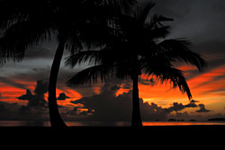
Southwest and South Coast:
The beaches of the hilly southwest corner of Antigua are generally less developed than those around St. John's further north. On the road that winds along this coast are Fryes Bay, Darkwood Beach, and the beaches around Johnsons Point. Rendezvous Bay and especially Doigs Beach, both located on the central southern coast at Rendezvous Bay, are especially quiet beaches worth the rough travel necessary to reach them. Pigeon Point, near English Harbour Town, is a convenient balm after a day at Nelson's Dockyard.

East Coast:
On the southeast corner of the island is Half Moon Bay, now a National Park and a good choice for a family outing. Long Bay, on the easternmost point of the island, is another good choice for families, as it is completely protected by its reef.

Thursday, August 4, 2011

Sicily, Italy

SICILIAN ISLANDS

Saline di MarsalaSicily comprises a number of satellite islands and archipelagoes of high tourism importance.

The Stagnone Lagoon

The Stagnone Lagoon covers an area of 2,000 hectars between Punta San Teodoro and Capo Lilibeo. It consists of a small archipelago composed of four islands, namely Longa, Scuola, Mozia (or San Pantaleo) and Santa Maria. In 1984, in order to preserve its precious ecosystem, the lagoon was designated as a Natural Reserve.

Villa romana di MoziaMozia

Mozia, set off Marsala’ s Stagnone Bay, was inhabited by the ancient Phoenicians. With its characteristic salt-pans and wind mills, the island is a major goal of tourists. Besides its naturalistic riches, the island is an equally renowned archaeological site, with the Tofet, a place where Phoenicians buried children, and the archaeological museum.

Pantelleria - scoglio dell'elefantePantelleria

Pantelleria, in the Trapani district, is among Sicilian major tourist destinations. It is well-famous for its dammusi, naturalistic riches and sites, like the Montagna Grande (Grand Mountain), pine woods, the Gibele volcano, the favare and several archaeologic sites, like the Monastero catacombs and the abandoned village of Mueggen.

It is a volcanic island rather closer to the African coast (37 km from Tunis) than Sicily’s (47km). The last eruption dates as far back as 9,000 years while sysmic’s dates back to the late-1800s. The sole active volcanic activity is due to the so-called Stufe or Bagni Asciutti hot springs and the favare, mini-geysers that puff boiling hot steams. The main one, known as the Favara Grande, stands down the slopes of the Grand Mountain.

The dammuso, from Arabic for ‘vaulted structure’, is a typical 10th century building with arch openings, stone walls and a dome-shaped roof serving to collect rain. The walls’ considerable thickness insulates the rooms, keeping them cool in the hot summer.

PantelleriaPantelleria boasts remotest origins: relics of lava stone artefacts from the Phoenecian Age are scattered across the Island; among these are the noted Sesi – tombs where the important members of the community were buried, made from lava stone blocks – and the ruins of a pre-historic village.

Visitors may take splendid excursions on horseback along the island naturalistic spots and boating tours of the many bays and bathing spots. The Ballata dei Turchi, the Tracino, the Formaggio are just a few names.

The island is especially beautiful in the spring and autumn when the climate and a slower flow of tourists afford a more relaxing vacation, away from mass tourism.

Ustica

Ustica, belonging to the Palermo province, has such attractive and renowned natural bays as the Cala Santa Maria, the Bastione Monte Guardia dei Turchi, the Cala del Camposanto, the Punta dell’Omo morto. As much impressive spots are provided by the natural caves of the Grotta Azzurra and the Pastizza. The only village on the island, mainly living on fishing and tourism, and the fine Bourbon tower are other major features of this enchanting place.

Ustica is an oasis of peace and tranquillity, unspoilt by mass tourism, hence affording an extremely relaxing holiday amidst historical and naturalistic attractions. Diving is most recommended.

The island boasts an important history; it was inhabited by the Phoenicians and the Romans, the latter calling it Ustum, meaning “burnt”. Since 1986, it has been a marine protected reserve.

Aeolian Islands

Vulcano - EolieThe Aeolian Islands, within the Messina province, are situated off Milazzo coast. These seven volcanic islands are a favorite destination for tourists from across the world. Their uncontaminated landscape marked by striking colour contrasts is host to a wide range of wildlife including several kinds of migratory birds and rare sea-gulls.

As other Sicilian archipelagoes, the Aeolian is one of remotest roots, the earliest settlements here going as back away as 4,000 years. It seems that the main Lipari has accommodated some Greek colonies. There is a fine and well-known museum tracing, through a rich display of artefacts, the islands’ history starting from the very Paleolithic age when the islands are reckoned to have emerged from the sea. Today, tourism constitutes the islands’ main income.

LipariThe cone-shaped Alicudi, the farthest island – along with Filicudi – from Milazzo coast, has characteristic lava stone houses and a richest flora mostly composed of prickly pear, caper and broom. It is endowed with some beautiful beaches, crystal-like waters and very interesting architectural sites, such as the churches of the Carmine and St. Bartholomew, the Montagna, being a settlement dating back to the 18th century, and the village of Castello, set on a hill sloping down to the sea.

The neighboring Filicudi is also very attractive. Remnants on the island provide evidence for human presence there since Antiquity: the ruins of a pre-historic village dating back to the Bronze Age and the sites of Rocca Ciauli, the Montagnola, Capo Graziano, Monte Guardia.

LipariTwo villages have grown on the island, namely Valdichiesa and Zucco Grande. The wild nature, along with the sea and the beautiful shore, have made the island a favorite destination of summer tourists. Not to miss is the boating tour of the island, enabling visitors to enjoy every natural side of this magic place.

Stromboli, especially renowned for its active volcano, is a popular tourism destination. It is particularly impressive at sunset when its landscape puts on incredibly beautiful colours.

LipariSalina, with its richest flora and its distinctive two-humped profile – consisting of its two peaks Monte dei Porri and Fossa delle Felci, is the second largest of the Aeolian Islands. It derives its name from an old salt mine there located. Today, Salina is a well-famous tourism – notably summer – resort combining historical – the Santuario della Madonna del Terzito and the Santa Marina district with several caves of Saracen origin – naturalistic – the Pollara Bay, the Lupo Valley – and bathing spots.

Vulcano is the southernmost of the Aeolian islands and the closest to the Sicilian mainland.

It results from the fusion of four volcanoes. The main crater, the Cavallo and the Gelso caves, being nicest bathing spots are most attractive.

Lipari is the largest and by far the most popular of the Aeolian islands; the visitors can enjoy numerous attractions, finest sand beaches and the charming town’s old centre. The Castle overlooking the sea and housing the Archaeological Museum, the Norman Cathedral, the Greek amphitheatre and a number of villages, such as Canneto, with its nice sand beach, and Acquacalda are worth a visit.

Cattedrale di LipariLike other islands in the archipelago, Lipari is one of archaeological interest, with relics ranging in date from the 17th to the 2nd century BC. Outstanding are the most ancient San Calogero Thermes – going as back away as the 17th century BC –, a necropolis with tombs dating from the 5th century BC and the ruins of two sanctuaries dedicated to Demetra and Kore, dating back to around 470 BC. Also worth-seeing are the Monastero di San Bartolomeo restored at the behest of Norman Count Roger, the Rocche Rosse crater, the pumice quarry and the old kaolin mines.

The island of Panarea is especially appreciated by Italian and International VIPs. Outstanding are the Cala Junco green bay and the ruins of a prehistoric village dating back to the Bronze Age.

The Pelagian Islands

LampedusaThis beautiful archipelago is made up of the renowned Lampedusa,Lampione and Linosaislands; and belongs to the Agrigento province.

The Islands are at a considerable distance from the mainland, what has helped preserving their primeval environment.

LampedusaLampedusa, by far the most famous island in the Archipelago, is home to archaeologic remnants from Phoenician, Greek, Roman and Arab ages. It is endowed with beautiful naturalistic sites; worth-mentioning are the Cala Spugne, the Cala Maluk and the Rabbit island. The island has a richest vegetation and wildlife and unique landscapes. Its geological features are very much alike the Northern coast of Africa. Boating tours of the coast and its finest sand beaches are highly recommended. The Santuario della Madonna di Lampedusa or Porto Salvo, a church whose origin goes back to the Age of the Crusades, is worth-seeing.

LinosaLinosa, known as the “black pearl of Sicily” due to its volcanic origin, has uncontaminated environments and sea-beds with plenty of grottoes, caves and wildlife. The island is a paradise for snokelers and divers. Its vegetation is magnificent. The island origins go back to the Roman and Arabian dominations.

Lampione, also known as Scola dei Portolani, is a smallest desert island closest to Lampedusa.

The Egadi Islands

MarettimoThe Egadi Archipelagolies a few miles off Trapani shore and comprises the three main islands of Favignana,Levanzo and Marettimo, plus a a number of tiny islands among which stand Asinelli and Formica, home to remains of a tuna-fishery and a lighthouse.

FavignanaOn Marettimo, there are remains of ancient Roman settlements, namely the grand Grotta del Cammello (Camel Grotto) and the rocky peak of Punta Troia, where lie the ruins of an ancient Aragonese castle. The island is endowed with splendid naturalistic riches, uncontaminated sea-beds, like that by the Cala Bianca, the Bombarda grottoes and several interesting hilly areas like Pizzo Falcone and Pizzo Capraro.

LevanzoFavignana is the major and the most frequented island of the Archipelago. It has a hilly profile, a rich vegetation, mainly Mediterranean, amazing coastal strips like Cala Rossa, and spots as the Bue Marino grotto, Punta Fanfalo, Cala Grande and others.

Levanzo, with its characteristic small bays, grottoes and prehistoric remnants, is a beautiful island in the Egadi archipelago. Its former names Phorbantia and the Arabic Al Yabisah (meaning “dry”, due to lack of fresh water springs on the island) provide evidence for its remote roots.

Wednesday, August 3, 2011

Mauritius


Mauritius Islands can be described as 'the paradise on earth'. The name Mauritius islands conjures up vibrant images of pristine beaches, blue sea with a backdrop of beautiful mountain ranges, lush green vegetation and exotic places of tourist attractions.

Mauritius Islands or the Republic of Mauritius is located in the middle of Indian Ocean. Spread over an approximate land area of 2,040 square kilometers the island is located within the geographical co-ordinates of 20.17 degrees South and 57.33 degrees East. The geographical location of Mauritius has influenced its climate. Climate of Mauritius Islands is essentially tropical characterized by warm, hot and humid summers and cold winters. Mauritius archipelago comprises of two islands. First is Mauritius, and the other island is Rodriguez located some 500 kilometers away from the main island. Peak tourist season in Mauritius is during the Christmas and New Year Period. Apart from that, the best time to visit Mauritius is from July to September.


Mauritius Islands is a favored tourist destination as it is dotted with tourist attractions. Port Louis the capital city is nestled in the foothills of the mountains. The French style architecture adds to the charm of this city. Several museums like the Natural History Museum and the Worldwide Masks Museum offer are places of interest. Chamberer is one of the oldest sites in the island. It is also known as the seven colored earth as it is made up of patches in blue, green, red and purple. These are probably the result of erosion of volcanic rocks. Royal Botanical Garden of Pamplemousness, Grand Bass in, Ilse Aux Cerf's and the Black River Gorge are among the other attractions.


Chagos Archipelago is one of the most beautiful group of islands in Mauritius. Chagos Archipelago consists of nearly 60 small islands which are spread over an area of about 50,000 square kilometers. Chagos Archipelago is characterized by the large number of faultless coral reefs that surround it. Mauritius acquired administrative rights over this archipelago in 1903.

Location of Chagos Archipelago

Chagos Archipelago is situated in almost the center of the Indian Ocean. Chagos Archipelago lies 450 kilometers on the southern part of Addu and is 1,460 kilometers away from Sri Lanka.

Islands of Chagos Archipelago

The largest island of Chagos Archipelago is known as Diego Garcia. Diego Garcia alone covers an area of 28 square kilometers. Chagos Archipelago also consists of five atolls, which are known as Blenheim Reef, Egmont Reef, Diego Garcia, Salomon Islands and Peros Banhos. There are also a number of small islets in Chagos Archipelago such as Ile Aigle, Ile Pierre, Ile de Coin, Ile Sude-Est, Ile de Coin and Ile Boddam.

Climate of Chagos Archipelago

The sea winds make the weather of this island pleasant and comfortable. The south-easterly winds cause a moderate winter between the months of June and September. The Chagos Archipelago receives maximum rainfall between the months of December to January.

Fauna of Chagos Archipelago

These islands provide shelter to a large number of rare birds such as Red Footed Booby, Brown Noddy, Sooty Tern, and Lesser Noddy. Green and Hawksbill Tortoises can also be spotted in this island.


Rodrigues
is one of the most popular and most beautiful Mauritius islands. It is situated at a distance of 550 km from Mauritius and is known as the tenth district of Mauritius. The capital of Rodrigues is Port Mathurin, which is situated in the northern part of the island. Creole is the most commonly spoken language in the island.

The best way to reach Rodrigues is to avail the flights to Sir Seewoosagur Ramgoolam International Airport in Plaisance. From this location a boat ride ensures a comfortable journey for the tourists into Rodrigues.

Attractions of Rodrigues

The sandy beach of Rodrigues provides an ideal spot to enjoy the sunbath for the tourists. The tourists can also enjoy fishing to the heart's content. Few of the other attractions in the island include Port Mathurin's stadium, Saint-Gabriel Cathedral, Mosque of Port Mathurin, Rodrigues Regional Assembly. Rodrigues is also popular for its rich flora and fauna.

Climate of Rodrigues

The climate of Rodrigues remains pleasant almost throughout the year. The summer temperature remains in between 29?C to 34?C, while the winter temperature fluctuates between 15?C to 29?C.

Accommodations in Rodrigues

Few of the renowned hotels in Rodrigues include La Ravenal, Cotton Bay Hotel, Pointe Venus Hotel. The hospitality in these hotels has been highly praised by the guests.

Economy of Rodrigues

Fishing and animal rearing are the two most important sectors of the Rodrigues economy. The economy of Rodrigues earns most of its revenues from fishing and animal rearing. The handicraft industry of the country also proves to be very beneficial for the economy of Rodrigues.


Tromelin
is one of the most beautiful and important Mauritius islands, and according to the history, this island was first discovered by the French in 1776.

Tromelin is situated in the Indian Ocean and lies east of Madagascar. The total land area of Tromelin an island in Mauritius is estimated to be 1 square kilometer. Tromelin Island is located at the latitudinal coordinates of 15 ? 52’ South and the longitudinal coordinates of 54? 25’ East. It is an uninhabited island and there is no option for a long stay for the tourists.

Tromelin is mostly visited by the scientists. A meteorological station has been established in this island. This station helps considerably in the forecast of cyclones on the Indian Ocean. The landscape of Tromelin consists of plains, and low lying areas. There are also sandy areas in this island. The coral reefs surround a big portion of the island.

Tromelin island experiences tropical type of climate. Therefore, the climate of Tromelin island supports the survival of different types of vegetation in the island. The soil is also very fertile and enables good growth of the trees. Tall grasses and different types of bushes can be seen in most part of the island.

Tromelin island is also known to be one of the important wild life havens in the world and bird watching can really be interesting here. The spectacular island supports a large tortoise population and other species of sea animals.

There is an airstrip in the island, where the tourists can catch a flight to Sir Seewoosagur Ramgoolam International Airport in Mauritius. The tourists can reach Tromelin Island in Mauritius by availing flights. Within the island, the tourists can take walk and enjoy the different species of flora and fauna.


The Agalega Islands of Mauritius comprises of two islands namely the North Island and the South Island. These beautiful islands are located in the Indian Ocean, at a distance of 1122 kilometers north of Mauritius. A stretch of sand bank separates the two islands. The Agalega Islands cover a land area of 70 square kilometers.

Tourists are able to reach this island either by sea or by air. The boat ‘Mauritius Pride’ sail to the Agalega Islands everyday with thousands of tourists. By air the visitors can reach this island by a Dornier aircraft, which belongs to the Coast Guard Department of the Mauritian Police Force.

Agalega Islands at Mauritius are dotted with small picturesque villages. Vingt Cinq and la Fourche are the two villages in the North island and Ste Rita is the only village in the South Island. The Vingt Cinq village is the main village, housing all the administrative infrastructures. This small village also has schools, a hospital and a church. A meteorological and a wireless transmitting and receiving station is there in this island. La Grande Case is the main administrative headquarters of Agalega Island. Tourists can have their meal in La Grande Case. Both the islands have generator sets for supply of electricity from 10.00 am to 11.00 am in the morning and 6.00 to 10.00 pm in the evening.

Agalega Islands in Mauritius is famous for coconut trees. These islands produce copra and coconut oil for export. Animal husbandry and poultry are the prime source of livelihood and different kinds vegetables are also grown in these islands. Visitors can also spot the Agalega Island Day Gecko, an endemic species of gecko, unique to these islands.

Agalega Islands of Mauritius charm the tourists with an inherent rustic charm. The natural beauty is simply appealing.


Cargados Carajos is a collection of low islets, coral reefs and sandbanks located 350 kilometers north east of Mauritius. It is popularly referred to as Saint Brandon. Cargados Carajos shoals are a group of 16 small islands and islets. These islands support scanty population spread over a total land area of 1.3 square kilometer. This group of islands is a popular tourist attraction of Mauritius because of the exotic coral reefs and the rich variety of flora and fauna found in these islands.

Cargados Carajos Islands

Numerous unnamed islands are located in Cargados Carajos. There are around 40 islands located on this reef. The Siren Island, Frigate Island and the Pearl are located on the western reef. Albatros Island is famous, as it is the single coral island located 18 kilometer north. Majority of the population is concentrated in the Raphael Island. This beautiful island houses a fishing station, a meteorological station and a coast guard. Avocare, Cocos and Sud are smaller settlements.

Cargados Carajos Flora and Fauna

Thickets, bushes and shrubs are the main vegetation that covers these islands. A carpet of thick granular sands cover these islands. It is a result of coral erosion from the reefs. They form an ideal nesting site for the green sea turtles for laying and hatching their eggs. Cargados Carajos islands also supports a large migratory sea bird population. Keen birdwatchers can spot different varieties of sea birds in this area. Roseate Tern, Brown Noddy, Lesser Noddy, Common White tern afe different kinds of birds found in this island.

The fascinating Cargados Carajos attracts thousands of tourists with its coral reefs and diverse species of flora and fauna.

The Islets of Mauritius
The main island of Mauritius is surrounded by a number of islets. Some of the islets of Mauritius are close to the shore, while others are located far away and some are inaccessible. Some of these islands have rich natural reserves of endemic species of flora and fauna. Some of these islands are also known for their beaches and coconut plantations and are frequented by tourists.

The islands of the Islets of Mauritius include Ile Aux Aigrettes, Ilot Aigrettes, Ile De La Batterie, Ile Aux Benitiers, Pte Bernache, Ile Camisard, Ile Aux Cerfs, Ile Aux Chats, Ile Des Deux Cocos, Ilot Flamants, Ile De L’Est, Ile Aux Fous, Ile Aux Fouqets, Ilot Fourneau, Ilot Gabriel, Matapan Island , Ilot Levrettes, Ile De La Passe, Ile Marainne and many more.

Ile Aux Cerfs is one of the most charming islands near the east coast of the island of Mauritius. This is an island with exotic beaches and is the most coveted tourist destination. Tourists can dabble in various water sports, and enjoy their excursion with their whole family. For accommodation the visitors can stay in the five star hotel with a golf course. Isle de la Passe is a unique island situated in the bay of Grand Port on the island of Mauritius. This island is a witness to the gory and the fierce battle between the British and the French. Coin du Mire is popularly referred to as Gunner’s Quion. This islet of Mauritius is of its eastern coast. The Dutch settlers had occupied and settled in this island. The remains of sugarcane plantation validate their existence. The Coin du Mire Hotel is a favorite abode for the tourists.

Ile D’ Ambre is one of the largest islets surrounded by other satellite islands. Ile Mounick, Matapan Island and Ilot Canarde are the small islands. Point Bernache is a stunning islet of Mauritius located near Ile D’Ambre. The island is surrounded by a lagoon, which is apt for angling and fishing. The Flat Island is the extreme north islet in Mauritius. This island houses two magnificent lighthouses in Mauritius. The Grand Port Islets of Mauritius are made up of small volcanic island. Most of these islets have submerged with the rising tide.

The Round Island lies 22.5 kilometers north of Mauritius. This island features as an exclusive nature reserve. Spread over an area of approximately 1.69 kilometers it supports different endemic species of fauna including the Round Island skink, Round Island day gecko and Round Island Boa. The Serpent Island is one of the inaccessible and remote islets of Mauritius. This island is void of any kind of vegetation and is covered with a layer of guano, a type of volcanic ash. This makes it a favorite abode for nesting of sea birds. Most common seabird species spotted in this islet are the Sooty Tern, Brown Noddy and Lesser Noddy.

The islets of Mauritius offer a variety of experience to the foreign tourists. Some of the islets have exotic beaches and other are of historical significance, while some others charm the visitors with their untouched natural beauty and the rich flora and fauna.

The island of Rodrigues in Mauritius has attracted flocks of tourists with its usual charm. It is also the tenth district of the Republic of Mauritius. The island of Rodrigues is located 550 kilometers north east of Mauritius. The volcanic island covers an approximate land area of 110 square kilometers and is 18 kilometers long and 8 kilometers wide. Visitors also throng to see the sheltered lagoon, which covers an area of 200 square kilometers. Port Mathurin, the capital of Rodrigues is located in the north. Surrounded by a dozen of islets, Rodrigues is an ideal island retreat of Mauritius.

The tranquil and serene surroundings of Rodrigues has a lot to offer to the tourists. The simple and yet charming life of local people here have impressed the travelers. The local inhabitants of Rodrigues believe in preserving their natural environs. Many endemic species of flora and fauna are abundant in this island. Among other activities the tourist can enjoy birdwatching and test their angling skills. A visit to some of the caves in this island is a wonderful experience. The natural stalactites and stalagmites take different shapes and are interesting to watch. Hikers can even enjoy a hike around the island enjoying the scenic beauty. Climate of Rodrigues island is soothing and pleasant. Summer temperatures vary between 29 degrees to 34 degrees celcius and the winter temperature varies between 15 degrees to 29 degrees celsius.

Rodrigues in Mauritius is easily accessible by air. There is a thin air strip in this island. Rodrigues offers the best of breathtaking natural beauty coupled with variety of leisure activities.


Round Island is one of the islands in Mauritius situated 22 kilometers north east of Mauritius. This island is a part of a an extinct volcanic cone, which has been partly submerged under water. Covering a land area of approximately 150 hectares, the altitude of Round Island is around 300 meters above the sea level. Round Island in Mauritius is made of layers of volcanic ash, which have been deposited over the years to form hard compact layers.

Round Island in Mauritius is an ideal refuge for numerous species of sea birds and a diverse species of flora and fauna. These form the main tourist attractions of Round Island. Government of Mauritius have taken initiatives to evolve and develop Round Island as a rich ecological reserve. In the early 19th century extensive damage was done to the natural vegetation due to the grazing of animals like goats and rabbits. Grazing loosened up the soil and there was 90% soil erosion. From 1986 Don Merton and his team were consciously engaged in reviving and restoring the natural habitat of this island by planting unique plant species.

In the recent years, Round island though a deserted island supports some of the endemic species of fauna like the Round Island day gecko, Round Island skink and Round Island Boa. The untouched rustic beauty of Round Island charms and enthralls the tourists.